Alberta Ecosystems
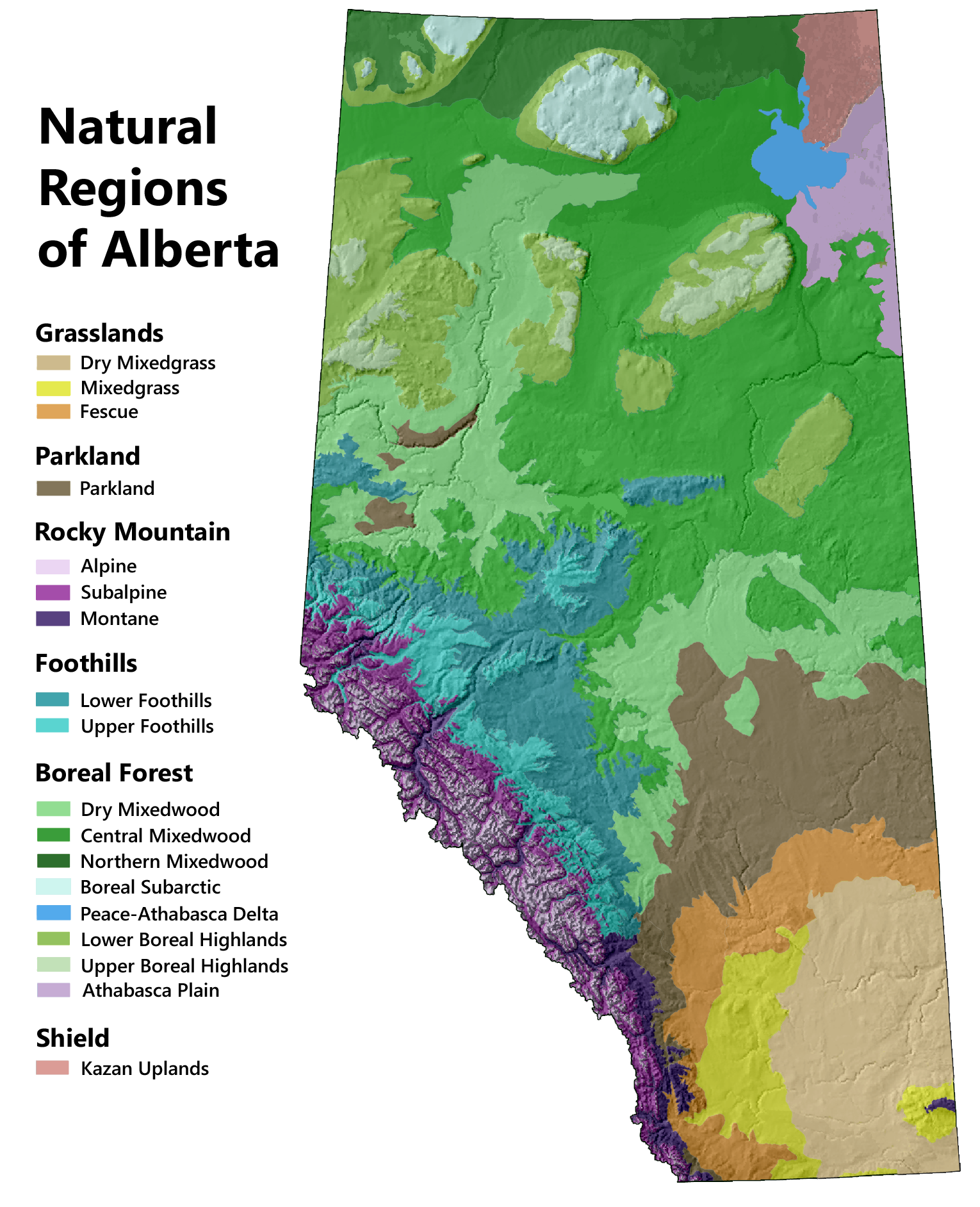
There are six distinct ecosystem types in the province, referred to as Natural Regions, and each has its own mixture of flora and fauna. The maps below provide an introduction to these regions and their underlying physical features.
Topography
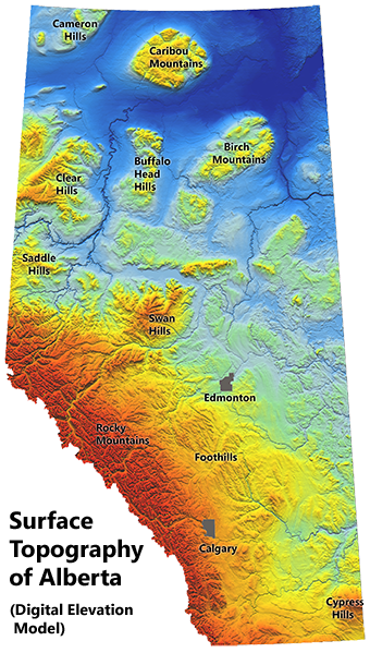
At the regional scale, the distribution of plants and animals is determined mainly by major landscape features and broad climatic patterns. In Alberta, the most important topographical features are the Rocky Mountains and adjacent foothills. Elevations progressively decline as you move away from the mountains and are lowest in the northeastern corner of the province.
In northern Alberta, the generally flat landscape is interspersed with a system of large hills, unrelated to the Rocky Mountains. There is also an important hill system in the southeastern corner of the province, referred to as the Cypress Hills.
Elevation is an important driver of ecological patterns because the average temperature declines the higher you go. Mountains, and to a lesser extent large hills, also experience greater precipitation than surrounding landscapes.
Click the map to view it at full size.
Climate
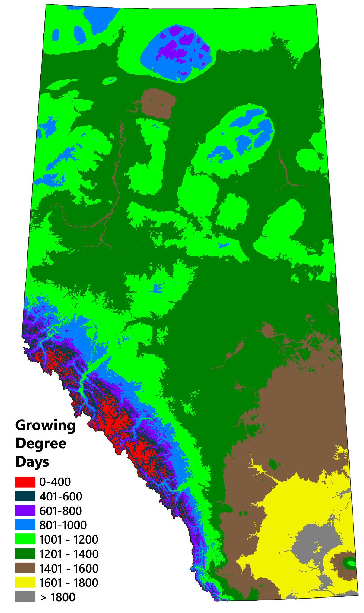
To a large extent, regional ecological patterns reflect regional climatic patterns. The average annual temperature is a key factor, along with the average maximum and minimum temperatures over the course of the year. Northern latitudes are colder than southern latitudes, and high elevation areas are colder than low elevation areas.
The adjacent map illustrates regional temperature patterns in terms of growing degree days. What you see is the cumulative temperature for days that are warm enough for plants to grow — a key determinant of vegetation patterns.
Precipitation is also an important driver of ecological patterns. The mountains and foothills block much of the rain and snow coming in from the Pacific, so average precipitation rates are substantially higher here than in the rest of the province.
The interaction between temperature and precipitation is also important. Areas of higher temperature experience higher rates of evaporation, and this reduces ground moisture. For example, Calgary and Fort McMurray receive roughly the same amount of precipitation; however, the rate of evaporation is much higher in the warmer south. Consequently, despite similar inputs, only the Fort McMurray region maintains sufficient levels of soil moisture to support a forested ecosystem.
Natural Regions of Alberta
Areas of similar topography, climate, and soils tend to support similar communities of plants and animals. Together, the living and nonliving components of such areas constitute distinct ecosystem types. Alberta's system of land classification describes six major ecosystem types, called Natural Regions, which in turn are divided into 21 Natural Subregions.
River Systems
Alberta's landscapes are drained by seven major river systems. All of these rivers, except for the Battle River and Beaver River, originate in the eastern slopes of the Rocky Mountains. Because Alberta's topography slopes to the northeast, its rivers generally flow east or north.
Rivers are important landscape features and affect ecological patterns in several ways. Riparian areas are often wetter than the surrounding landscape and therefore host different plant and animal communities. Simply bringing water into a region is a critical function in dry areas such as the Grasslands. In many places, rivers have created deeply incised banks and valleys that provide habitat diversity. And for many species, rivers and associated riparian areas serve as important movement corridors.
Given their ecological importance, rivers are often the focal point of nature trips, either by canoe, or on foot along the shoreline at accessible locations.
Species Distributions
Individual species respond to climate and physical landscape features in their own way. Some are generalists, found throughout most of the province, whereas others are habitat specialists, found only in specific locations. In recent years, several online tools have become available to help naturalists find species they are interested in.
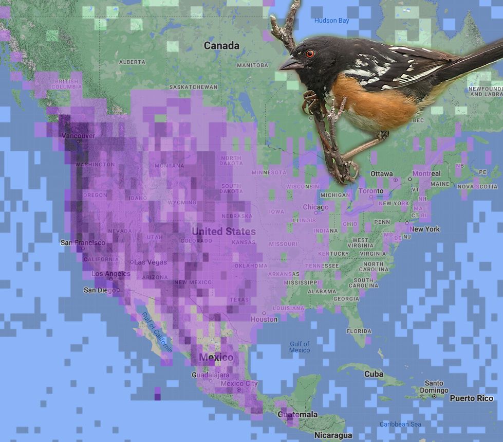
The eBird Explore webpage provides a gateway to the eBird database, a tremendous resource for learning about and locating specific bird species. By entering the name of a species in the "Explore Species" section of the webpage (top left) you can view a written description of the bird as well as photos, audio recordings, and a range map.
To view local sightings of a species you have an interest in, use the Species Maps page, which is accessible from the main Explore webpage. Initially, you will be presented with a range map showing a coarse index of abundance in shades of purple. Once you zoom in far enough, you will be presented with markers indicating the locations of individual sightings. Clicking on these markers will bring up a box displaying the date of the sighting and the number of birds seen.
The Explore webpage can also be used to to view specific regions of interest and local birding hotspots, providing a summary of the various species you are likely to see in a given area.
The iNaturalist Explore webpage provides a gateway to the iNaturalist database, another great resource for naturalists. Here you can find a listing of all the species that have been observed in a given location during a specific window of time. Alternatively, you can limit the observations to a specific species or group (like mammals) and determine where they have been found. Results can be viewed either in list form or on a map. Each observation is accompanied by one or more photos, its GPS location and a time stamp.
Alberta Biodiversity Monitoring Institute
The Alberta Biodiversity Monitoring Institute (ABMI) conducts periodic surveys of 1,656 permanent sites located along a systematic grid that covers the entire province. The objective is to document all of the species present during each site visit (to the extent possible). These observations are augmented with data from remote cameras and automatic sound recorders (for identifying species with distinctive calls). iNaturalist has far more observations overall, which is very helpful when it comes to monitoring uncommon species. However, ABMI's systematic grid approach eliminates the location bias and species bias inherent in iNaturalist observations.
ABMI monitoring data are available to the public on the ABMI Website. The Biodiversity Browser section provides distribution maps for a wide range of species (especially birds). The site also provides a variety of downloadable maps and datasets, including a provincial human footprint map.

