Hiding in Plain Sight: The Legacy of Fossil Fuel Industry Disturbances
29 September 2023

BY KEVIN P. TIMONEY
The ability to identify contamination and ecological impairment is becoming increasingly important as the pervasive effects of the fossil fuel industry come to light. Municipalities and individuals are coming into contact with an expanding network of industrial landscape disturbance which presently exceeds 30,000 km2 in Alberta (Fig. 1). Stories continue to surface of towns and homeowners that discover they have built on or are living alongside contaminated sites, whether that’s in Calgary, Sherwood Park, Didsbury or elsewhere.
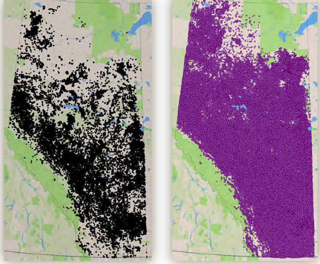
Distribution of 80,417 spills (left) and 504,583 energy industry wells (right), current to April
2023. KEVIN TIMONEY
The Alberta Energy Regulator is failing to inform the public of contaminated sites, so it is important to recognize the telltale signs, or signature, of contamination. In the aftermath of a spill or after abandonment of a wellsite or other industrial disturbance, the ecosystem responds to the altered conditions. The response creates a disturbance signature in the form of persistent shifts in the species present and in the chemical and physical conditions of the site relative to the natural, pre-disturbance conditions.
What clues tell you that you are observing a disturbance signature? First, it’s important to dispel two common misconceptions:
- Green plants mean the vegetation is healthy, right? No. Greenness doesn’t connote health; it simply means that a site has abundant nitrogen and water. Golf greens provide an obvious example: the lush non-native turf is underlain by a soil contaminated with high levels of nitrogen, herbicides, pesticides, and fungicides, and in some cases the persistent heavy metal mercury used in fungicides until the 1990s. In contrast, many native, biodiverse communities are green for only brief periods each year and are muted in colour the remainder of the year (e.g., native grasslands).
- When a site has been revegetated, reclamation has been successful, right? No. Some plant species have a remarkable ability to grow on degraded or contaminated soil. The plants that dominate industrially disturbed sites are an assemblage of disturbance-adapted exotic species and a small number of common pollution-tolerant native species. It takes little or no reclamation for these plants to establish, but the resultant community is neither healthy nor biodiverse, nor does it provide quality wildlife habitat. Its soil has been biologically, chemically, and physically altered to varying degrees.
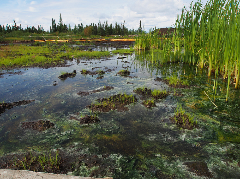
Green does not mean healthy. Here a contaminated marsh dominated by common cattail and cyanobacteria has replaced a native bog-fen at the Pace-Spyglass oil spill (58°23’9” N, 119°06’29” W). Residual crude oil remains in the wetland. KEVIN TIMONEY
Identifying Disturbance Signatures
Soil degradation is the common denominator at fossil fuel industrial disturbances, regardless of whether or not a spill has occurred. This degradation takes place at an early stage, as the native vegetation is removed and the topsoil is stripped off, taking with it the rhizosphere (root layer). The rhizosphere is the beating heart of the ecosystem and serves as a store of soil carbon, nutrients, and soil life forms. With the rhizosphere lost, so are the symbiotic relationships that connect the components of the ecosystem, impart resilience to stress, and allow the system to reconstitute after disturbance.
With the living topsoil gone, the site may be overlaid with fill and then compacted beneath heavy machinery during construction and maintenance. It may also be subjected to numerous spills (recorded and unrecorded), chemical applications (herbicides, bactericides, soil “amendments”), used for waste disposal (such as of drilling muds), and invaded by weedy species or seeded with “reclamation” species (typically competitive non-native and agronomic species). The result is a persistently impaired community, fundamentally shifted from the natural condition and normal successional processes.
Industrial disturbance signatures vary in their intensity depending on the type of disturbance. The most common types of disturbance can be placed along a gradient from least to greatest impairment:
- Low: low-impact seismic lines, conventional seismic lines, and temporary airstrips.
- Moderate: spills, pipelines, roads, and utility corridors.
- High: well sites, batteries, waste pits, dumps, tailings ponds, and processing plants.
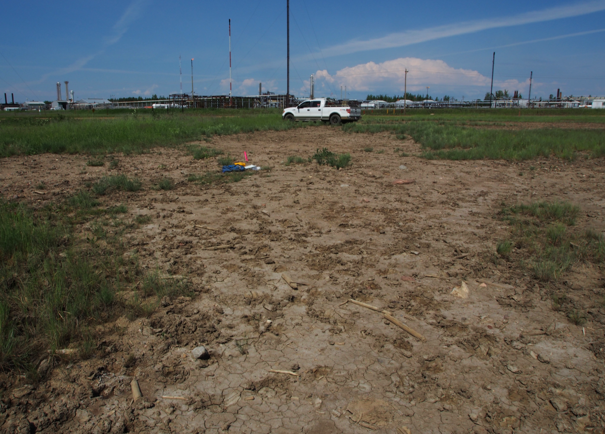
Identifying a disturbance signature in the field can be challenging. In some cases, you may see residual crude oil or a salt crust, or detect odours such as hydrogen sulphide from leaking or abandoned wells, or see industrial junk such as pipes, equipment, shacks, and debris. Sharp edges bounding a site provide another clue. Industrially disturbed sites have edges that are more abrupt and often more linear than natural edges, and these abnormal transitions will remain long after revegetation has begun. Because most laboratory assays can’t be done in the field and indicator animals may be absent during an observation, the best way to identify a disturbance signature lies in identifying the plant species present. Both the presence of unexpected species and the absence of common and normally dominant species convey information.
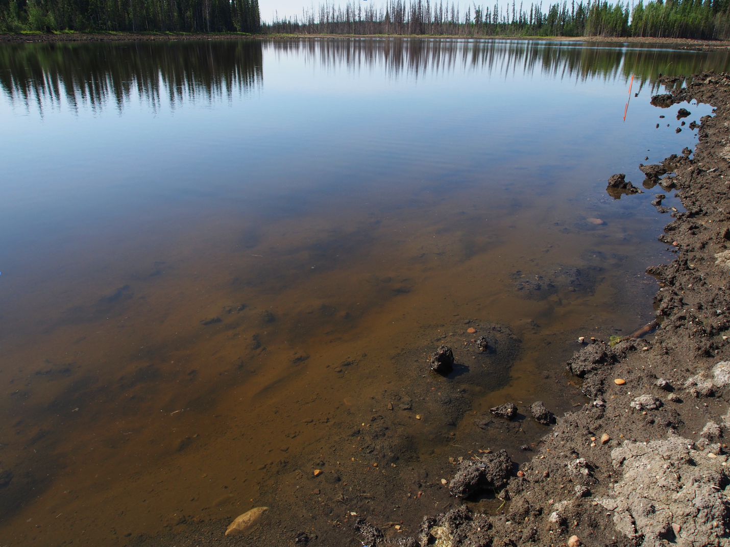
At this spill site, a formerly healthy bog-fen has been replaced by a pond with impaired chemistry, essentially devoid of life, and posing a risk to wildlife. Note the salt-killed conifers in the distance. KEVIN TIMONEY
Most disturbance signatures contain an abundance of weedy exotics, salt-tolerant plants (halophytes), grasses, and composites, many of which are pollution- and disturbance-tolerant. Lichens are absent at most disturbances. Mosses, if present, are cosmopolitan weedy species. The vast majority of native plant species are usually absent from industrial disturbances. Many abandoned contaminated industrial sites are nondescript weedy meadows.
The following species are reliable indicators of industrial disturbance across a range of upland habitats in western Canada. Among the exotic grasses are crested wheat grass, intermediate wheat grass, quack grass, smooth brome, Kentucky bluegrass (native and exotic elements), timothy, creeping foxtail, hard fescue, red fescue, sheep fescue, downy chess, orchard grass, and wild oats. Among the exotic legumes are alsike clover, red clover, alfalfa, bird’s-foot trefoil, yellow sweet clover, and white sweet clover. Among the exotic composites, annual hawk’s beard, Canada thistle, common dandelion, various sow-thistle species, pineapple weed, and scentless chamomile are good indicators. Other exotics include common plantain, summer cypress, redroot pigweed, and knotweed (Polygonum monspeliense). Increased abundance of cyanobacteria (blue-green algae) on land and in water are also good indicators. Native species that are common in some disturbances include aspen, biennial sagewort, common horsetail, common vetch, common yarrow, many-flowered yarrow, fireweed, and narrow-leaved hawkweed.
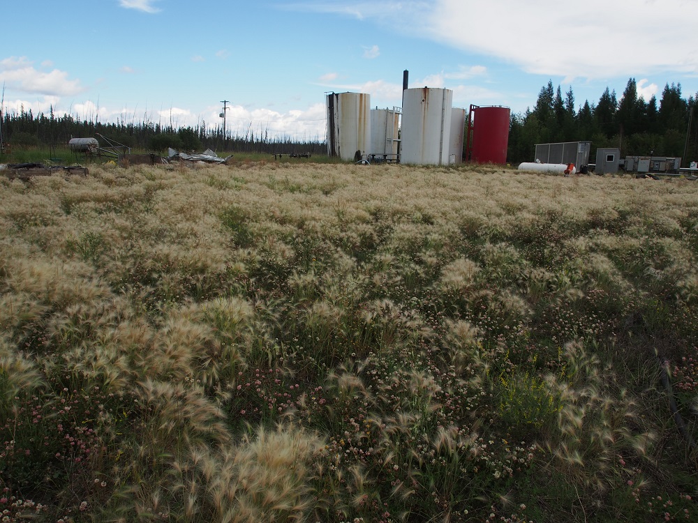
This damaged site has received multiple crude oil and saline spills. The soil is hardpan, in which few plants can grow other than the hardy foxtail barley and alsike clover. KEVIN TIMONEY
Ponds, marshes, moist habitats, and salinized soils have their own set of disturbance indicators. Among the grass-like plants (graminoids) are common cattail, small bottle sedge, water sedge, Nuttall’s salt-meadow grass, foxtail barley, fowl bluegrass, reed canary grass, rough hair grass, slough grass, bluejoint reedgrass, tufted hairgrass, short-awned foxtail, creeping spike-rush, alpine rush, and toad rush. Non-graminoid indicators include spiked water-milfoil, widgeon grass, marsh cinquefoil, marsh horsetail, meadow horsetail, spearscale saltbush, yellow rattle, and the alga, Chara.
Conversely, across a range of habitats in western Canada, there are indicators whose presence indicates a non-disturbed site. These include almost all woody plants, mosses, and lichens, and most native plants. In marshes and meadows, such indicators include awned sedge, common great bulrush, common tall sunflower, cordgrass, few-flowered aster, Macoun’s wild rye, narrow reed grass, northern reed grass, oak-leaved goosefoot, prairie bulrush, saline plantain, salt-marsh sand spurry, samphire, sea milkwort, seaside plantain, slender arrow-grass, spangletop, tufted white prairie aster, western willow aster, and western sea-blite.
Among the physical attributes that are observable in the field, good indicators of disturbance include abundant bare ground; decreased organic matter and plant litter; increased depth of active layer on permafrost soils; a replacement of mature pre-disturbance soils by young soils without horizons; soil water repellency; loss of soil structure, porosity, and permeability; increased soil hardness and compaction; and residual tar, oil, or salt crust.
Multiple saline spills at this pipeline site have rendered the soil permanently contaminated near a sour gas plant in northwest Alberta. Note the predominance of barren soil. KEVIN TIMONEY
Readers interested in biotic, chemical, and physical disturbance signatures for other ecoregions can find them described in my new book, Hidden Scourge.
What To Do
If you suspect you are living near a contaminated site, you may wish to get laboratory assays done. In soils, depending on the site’s history, you can expect elevated concentrations of petroleum hydrocarbons, polycyclic aromatic hydrocarbons, sodium, chloride, calcium, magnesium, and potassium, and heightened levels of electrical conductivity, sodium absorption ratio, pH, sulfate, heavy metals, and radioactivity. In water, again depending on the site’s history, you can expect elevated electrical conductivity, salinity, total dissolved solids, chloride, sulfate, sodium, iron, alkalinity, ammonium, naphthenic acids, barium, boron, bromide, lead, lithium, radium, selenium, strontium, vanadium, and endocrine disruptors, and residual tar balls. You can expect decreased pH in the case of acidic fracking water. Although the chemical signature in streams fades quickly as water flows downstream, it can persist in sediments.
At the landscape level, declines in biodiversity, animal abundance, and wetland extent are typical signatures. In wetlands, the disturbance signature is characterized by lost connectivity with other wetlands and an increased proportion of weedy wet meadows and marshes at the expense of peatlands. In uplands, there is an increase in weedy meadows and a decrease in native grassland, forest, and shrub vegetation, and of woody plants in general.
Knowing how to recognize disturbance signatures provides another tool for naturalists to understand landscape patterns, plant communities, and species occurrences. It may also provide an increased margin of safety for you and your family.
Kevin Timoney is an independent ecologist and award-winning author. This article is based on his recent book, Hidden Scourge: Exposing the Truth about Fossil Fuel Industry Spills. A compendium of evidence that accompanies the book is available by emailing lorax.ted@gmail.com.
This article originally ran in Nature Alberta Magazine – Fall 2023.
Read the Original Article for this Blog Post

For a richer reading experience, view this article in the fully designed magazine with all images and graphs in-situ.

This article originally ran in the Fall 2023 issue of Nature Alberta Magazine (Vol. 53 | No. 3).