Public Lands
Exploring Public Lands
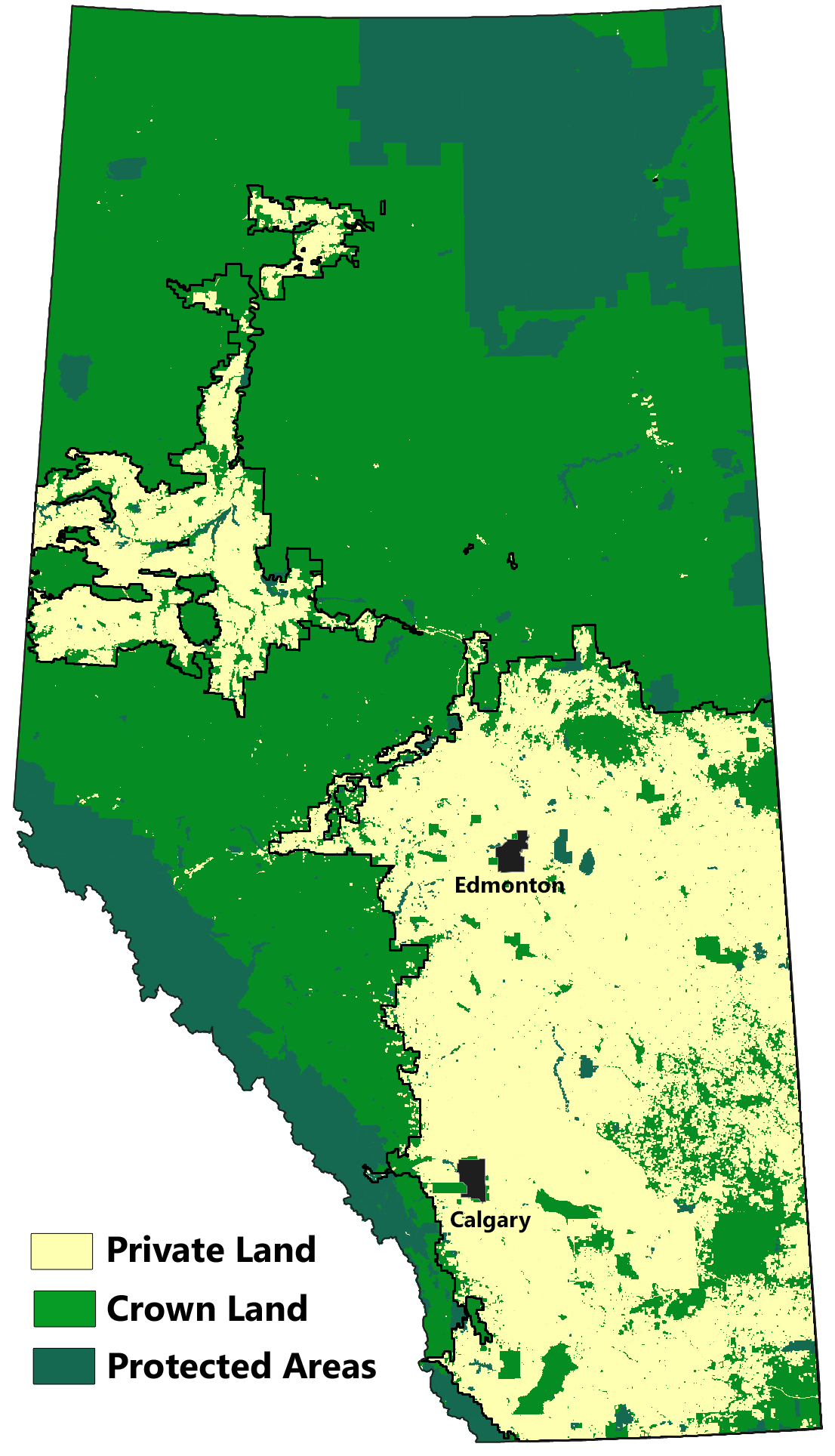
Over 60% of Alberta remains under public ownership (i.e., crown lands). The public has the right to access these lands; however, there are regulations governing both access and permitted activities. These regulations vary among regions, as described below.
Outside of protected areas, public lands are generally managed for multiple use. Except for the northeast corner of the province, most lands are leased to either forestry companies, oil and gas companies, or cattle ranchers. In many cases, there will be multiple leaseholders operating in the same landscape. Needless to say, these are busy landscapes, and for someone seeking to explore nature, it can be challenging to find spots that remain intact.
Google's satellite maps can be of great help in finding suitable sites, with reasonable intactness. Be aware that many of the roads shown in remote areas are industrial access routes that may be gated or otherwise impassable without an off-highway vehicle.
When exploring public lands you will generally be on your own. There are no visitor facilities and few established trails. Furthermore, cell service is usually unavailable, and there may be few other vehicles on the road. You need to come well prepared and let others know where you are going. A good approach is to save your intended destination in Google Maps and then share the saved pin.
White Zone and Green Zone
In the 1940s, the government divided the province into two zones: the White Zone, which included lands best suited to agriculture, and the Green Zone, which included lands best suited to forestry (see the adjacent map). As a result, most of the Green Zone remains today as crown land, whereas most of the White Zone is owned by individual farmers and ranchers. Some rangelands, especially in the drier southeast part of the province, were retained as crown land and are leased by the government to local ranchers.
In the Green Zone, public access is largely unrestricted. Random camping, hunting, fishing, and off-road vehicle use are all permitted, subject to fire bans and provincial laws. The government's Camping on Public Land website provides additional information about recreation in the Green Zone.
Public access is much more restricted in the White Zone. On privately owned land, permission of the owner is required. On crown grazing reserves, recreational users must seek permission from the lease holder.
Grazing Leases
Access to crown grazing reserves has been a point of contention between lease holders and recreational users. Agricultural leaseholders must allow access to the public as long as it poses no harm to the land or to their investment in crops, livestock, and property. However, recreational users must request access and follow the conditions prescribed by the lease holder.
The government has created a Recreational Access Mapping Tool to facilitate the process of requesting access. To use this tool, locate the area you want to access on the map that is displayed. Once you have zoomed in far enough, a township grid will appear with crown lands shaded in light green. At this point, click the menu item labelled "Identify Recreational Access" (up top) and then select a specific grazing lease. This will bring up the lease holder's name, contact information, and any specific conditions imposed by the lease holder. No information is given for private land holdings.
The government's Recreation on Agricultural Crown Land website provides additional information on the relevant regulations and user responsibilities in White Zone crown lands.
Camping Passes
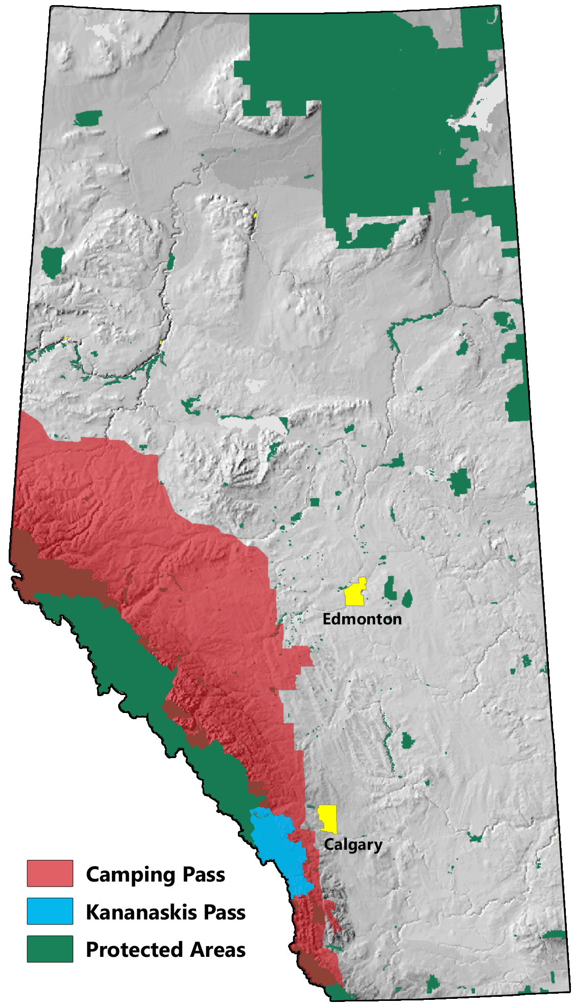
As a result of increased recreational use of public lands in the Eastern Slopes, the government has instituted a pass system for recreational users in two designated zones. The government has stated that it will use the fees collected to improve recreation experiences and to help conserve and protect the affected landscapes.
The first zone encompasses much of the Eastern Slopes (see map). A Camping Pass is required for random camping in this zone. Information on the pass and how to buy it is available on the Camping Pass Website.
The second zone includes Kananaskis Country and the Bow Valley (see map). A Kananaskis Conservation Pass is required to park a vehicle anywhere within this zone. Information on the pass and how to buy it is available on the Kananaskis Pass Website.
Riparian Areas
In Alberta, the province owns most of the beds and shores of naturally occurring lakes, rivers and streams, up to the high water mark. It also owns most of the beds and shores of wetlands if they are permanent and naturally occurring bodies of water. Additional information on water boundaries is available here.
Because riparian areas are classified as public lands, it is not trespassing to travel below the ordinary high water mark of rivers and streams bounded by private land, whether in a canoe or on foot. You can access the beds and shores of public water bodies via public road allowances and at bridge locations. Crossing over private land to reach a water body requires permission of the land owner.


